Site exploration in SE corner around Sunset Point
MONITOR: 1.5 hours: 4:00 PM to 5:30 PM
Scoped out SE corner of the property, assessing stand quality and treatment options.
Walked throughout the SE corner of the property, up through the horizontal hemlock thicket, out to the spectacular Sunset Point, then on up the southern property line to the monument marker at the SE corner. This was the first time exploring this area, and I wanted to get a good sense what’s involved with restoring the southern end of Eastern Wedge unit. It is so thick with small downed trees, that it is pointless to walk through without a chainsaw blazing in front of you. However, once this stuff is slashed to the ground, there appear to be plenty of robust, upright specimens to create a fine stand. The hemlocks in the extreme upper SE corner appear to have suffered less top-damage as the ones below. Some easy cleanup in the partially-harvested Sunset View promontory will make this a “go-to” destination, with a commanding view to the NW across lower Willapa Bay and Long Island. All the property lines in this area are essentially roughed-out trails following abundantly and brightly blazed trees, so there is no question as to where the boundary lies. There is also a monument marker in the SE corner (rather loose in the ground).
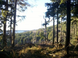
Sunset Point in the SE corner, looking NW over Clearwater Creek drainage, Willapa Bay and Long Island.
A remnant stand of hemlock and cedar provide the backdrop to this expansive promontory. A 6 year-old clearcut falls off down the slope in front, and a 16 year-old regenerated forest (native hemlock overtaking the planted Doug Fir) rises up the hill to the right (not pictured).
Continue Reading | Comments Off on Site exploration in SE corner around Sunset Point
Trail carving in Eastern Wedge unit
TRAILS: 1 hour: 3:00 PM to 4:00 PM
Started carving Eastern Hill trail (southern section) in Eastern Wedge unit #5.
Carved about 35 feet of East Hill Trail in Eastern Wedge unit #5, starting from the south end near the clearcut. More difficult cutting here with lots of hemlock and alder roots – sometimes the best tool is the hand saw to carve through the duffy soil and the roots all at once. Even though it produced a respectable trail grade, I may de-prioritize carving this section of trail because it is a good candidate for an official road extension from the High Landing. This extension would continue at a roughly level grade across a naturally established bench to provide the only viable access to the roadless Eastern Wedge unit. A small excavator would make the task much easier, and with a more enduring result.
Continue Reading | Comments Off on Trail carving in Eastern Wedge unit
Trail carving on West Ridge
TRAILS: 4.75 hours: 1:00 PM to 5:45 PM
Started carving West Ridge trail (middle section) in North Side unit #2.
Trail carving on West Ridge – north side of the creek: completed 240 feet in the middle section, starting from just below the steep upward bend (which I may re-route), down to the indentation from the side-stream to the east, where it levels out. Created a smooth “ribbon” throughout this length of trail, with just one steep section having old stump roots acting as steps. Cut the humps and filled the dips, aiming for a level cross-section. Also dug up several hemlock seedlings, evergreen huckleberry and false azalea that were in the trail route, hauled them back for transplanting at the farm.
Before and After: West Ridge trail looking east towards the lone cedar.
Only some slight carving here, some ferns and tree seedlings removed.
Before and After: West Ridge trail looking SW along ravine indent.
Some serious cut and fill here, big stump removal, lots of brush and seedlings to pull. Salvaged some Evergreen Huckleberry, False Azalea and some nice hemlock starts for transplanting back at Wild Thyme Farm.
Continue Reading | Comments Off on Trail carving on West Ridge
Trail carving on the south side of the RMZ
TRAILS: 2.5 hours: 12:15 PM to 2:45PM
Finish-grading of East Hill trail heading up through RMZ unit #3.
Carved and finish-graded the bottom 110 feet of the East Hill trail on the upper south side of the creek in RMZ unit #3, from the creek crossing up towards the Great Cedar Snag. Cut a fairly straight, moderate angle up the steep slope, eliminating the embedded wood chunks, humps and depressions along the way. Left two large wood chunks in the path that will have to be chain-sawed out. Large old logs lying parallel on the downhill side of the path provide much needed support. Without the logs as backstops, the downhill side of the trail has a tendency to slough off. The trail bed needs to be primarily carved INTO the hillside, rather than relying on the fill dumped to the OUTSIDE, which inevitably settles lower over time.
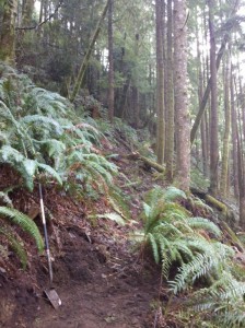
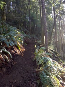 Before and After: East Hill trail.
The roughed-out route on the left is too lumpy with a lot of ankle-twisting side slope. The finished grade on the right has a consistent rise with a level cross-slope for stable footing. Many of the overhanging sword ferns were removed, as they tend to grow into and obscure the trail. This is a steep hill that we climb at a gradual angle to minimize erosion. This photo looks SW up the slope from the upper creek basin.
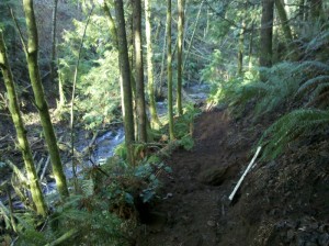 Finished East Hill trail looking back down to the creek.
Notice the big old log on the left (downhill side of the trail). It is firmly embedded into the hillside, and it provides a valuable support for the trail, allowing it to be widened here. We really need to carve into the bank to get a firm trail base, but fortunately the soil is soft and can be easily worked with simple tools like a pointed shovel. A few big wood chunks remain in the trail (behind the yellow axe), which will require a chainsaw to remove.
Continue Reading | Comments Off on Trail carving on the south side of the RMZ
Trail Carving on East Ridge
TRAILS: 2.25 hours: 10:00 AM to 12:15 PM
Finish-grading of East Ridge trail in North Side unit #5.
Carved and finish-graded 60 feet of the lower section of Eastern Ridge trail in North Side unit #2. Dug out stumps and rocks, shoveled dirt from high spots to low spots to create a smooth grade one to three feet wide. Maintained a fairly straight trajectory, occasionally diverting around or highlighting interesting features like bleached corkscrew roots and nurse logs. This trail showcases a lot of the wood “architecture” of this forest, both dead and alive.
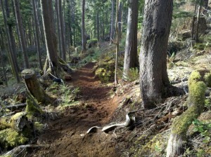 The end result of carving and finish-grading East Ridge trail.
It can be challenging to find an attractive, natural-looking route for a trail, especially in steep and lumpy terrain. This section of the East Ridge trail had some nice wooden architecture on both sides to frame and direct the trail down the slope. I dug out most of the stumps and rocks to create a smooth grade, but sometimes a unique feature like this exposed corkscrew root is worth incorporating into the trail to pause the flow like a log in a stream.
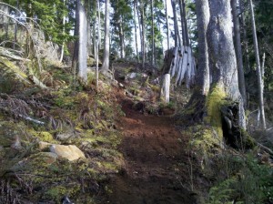 Finish-graded East Ridge trail, looking uphill.
I stopped the carving at a point where the trail heads sharply uphill to the left (in the middle of the picture). I may re-route the trail on a more gentle grade, perhaps via a switchback up next to the ancient cedar stump on the right. I don’t want to expend the effort and hack up the landscape until I have evaluated all the route options. The section I cleared was a “natural” route, pioneered by elk, so it made sense to turn it into a formal trail.
Continue Reading | Comments Off on Trail Carving on East Ridge
Forestry in the Collapsed Hemlock Thicket
FORESTRY: 2.5 hours: 3:00 PM to 5:30 PM
Slashing of brush and broken trees, plus thinning and pruning in the south side of Eastern Wedge unit #5.
Forestry portion of trail project in the south end of Eastern Wedge unit #5. Slashed down immense thickets of tall, decrepit salmonberry/elderberry brush, along with bent and broken hemlock clumps. Cut down the leaning alders and pruned the good ones. Turned an impenetrable zone into an accessible, attractive stand with good specimens and some room for new trees to grow in the small openings. Covered much of the area above the trail up towards the eastern property line.
Continue Reading | Comments Off on Forestry in the Collapsed Hemlock Thicket
Finished East Hill Trail
TRAILS: 4 hours: 11:00 AM to 3:00 PM
Finished the trail from the South Seep to the High Road in Eastern Wedge unit #5.
New trail creation. Finished the main trail through Eastern Wedge unit #5, connecting the north and south ends through the collapsed hemlock thicket on the south side of the seeps. Routed the trail a little higher than the path I roughed out the other day, to avoid a dip into a stream ravine. Ended up on higher, drier ground with a mellow stream crossing. Also placed a few cedar shake bolts as stepping stones across a wet area. Cleaned up the southern approach that had been roughed out weeks earlier, including slicing up and rolling away large, rotten log chunks.
Continue Reading | Comments Off on Finished East Hill Trail
Trail creation from South Seep to High Road
TRAILS: 1.5 hours: 4:00 PM to 5:30 PM
Roughed out a trail route to connect the South Seep to the trail from High Road in Eastern Wedge unit #5.
New trail creation – continued main trail through Eastern Wedge unit #5. Cut through the collapsed hemlock thicket on the south side of the South Seep, roughing out the final connection to the previously cleared trail coming from the south. Trying to keep the trail on the high side to avoid the dips into the stream ravines. Lots of low branch pruning on trees along the trail route.
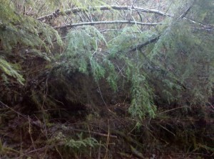 Collapsed hemlock thicket along the trail route south of South Seep.
Evidence of an ice storm or snow loading event is everywhere in this unit: entire collapsed stands, individual leaners, broken tree tops and hanging branches. Will have to cut through the middle of this to create the trail. Plenty of cleanup in the rest of the unit once the trail is established.
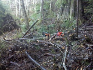 Slashed trees and brush at the edge of the collapsed hemlock thicket.
End result of cutting through the downed trees: “carpet-bombing” the forest floor. The trail will run along the right side of the photo, at the foot of the old cedar stump. Looking back north through the area just completed, the individuated trees are clearly visible. It is much easier to walk around in this unit now.
Continue Reading | Comments Off on Trail creation from South Seep to High Road
Trail revision through the Alder Seep
TRAILS: 2.75 hours: 1:15 PM to 4:00PM
Opened up a higher, more level route into the Alder Seep in Eastern Wedge unit #5.
Trail revision in Eastern Wedge unit #5. Cut a new route on the north side of Alder Seep to maintain the level grade as much as possible and avoid the original dip in the trail. Cut through the Doug firs on the hillside and emerged higher in the seep, with a gentle climb through the seep to the section on the south side. Test-carved the soft soil with the hand saw to create a level grade for walking – will return with a shovel and axe to finish the job. Only had to cut down one Doug fir (they are closely spaced here – this is one small part of the plantation that survived at close to its original stocking level).
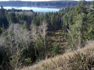 View to the SW over the mouth of Clearwater Creek Creek into Chetlo Harbor.
The body of water in the background is the tidal Naselle River (coming in from the east – on the left), emptying into Chetlo Harbor, a SE arm of Willapa Bay. Only a few residents and one oyster processing facility around this cove. Willapa Bay is the most pristine estuary on the west coast of the U.S.
Continue Reading | Comments Off on Trail revision through the Alder Seep
Trail revision across Clearwater Creek
TRAILS: 1.25 hours: 12:00 PM to 1:15 PM
Opened up a new upper creek crossing between the North Side and South Side trails in RMZ unit #3.
Trail revision across the creek. Opened up a new route across the creek at the upper end where the north and south side trails meet. The previous route was across “stepping stones”, but only works during low flows. About 25 feet upstream is a collection of old, large, mossy logs that bridge the creek, so I cleared paths to and across them. Extended the trail on the north side past the seep up to the log jam through dry terrain. Still need to carve the trail for better footing and deal with the wet section at the seep.
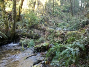 Newly opened creek crossing over big, mossy logjam.
About 25 feet up from the stepping stone crossing, this logjam will work for high water events. It has obviously been in place for a long time, with the creek managing to flow under and around it during many years of heavy rains.
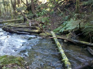 Original creek crossing over stepping stones.
Even with an extended winter drought, the stepping stones are partially underwater and this crossing can only be used during extremely low-water conditions (unless you have rubber boots!).
Continue Reading | Comments Off on Trail revision across Clearwater Creek



 Spirulina