Forestry work in the South Seep
FORESTRY: 4 hours: 1:30 PM to 5:30 PM
PC Thinning, brush slashing and broken tree removal in the South Seep in Eastern Wedge unit #5.
Forestry work in the South Seep area of Eastern wedge unit #5. A lot of alder branch pruning, up to the eastern property line and down into the lower part of the seep. Also slashed down ubiquitous old salmonberry and some red elderberry as part of the clean-up process. I do not expect the salmonberry to regenerate successfully in this closed canopy young stand. Heading south of South Seep, there is an immense amount of horizontal hemlock – whole clumps keeled over from what appears to have been an ice or snow loading event. Numerous broken tops on the Doug firs indicate this as well. Remarkable that the alder is mostly damage-free: beautiful, tall, well-spaced specimens. I noticed that some of the alders have broken lower branches – cracked and dangling, indicating snow/ice load damage rather than wind-based damage. Started slashing down the horizontal hemlock clumps (stems only a few inches in diameter) until I ran out of light. Constant drizzle soaked me thoroughly by the end of the day.
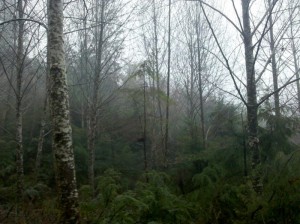 Suppressed Doug Fir in the Alder-dominated South Seep.
The lone, emaciated Doug Fir in the center of the photo (with a bird nest to the left of the trunk) was planted right after the clear-cut approx. sixteen years ago. This stand should be full of robust Doug fir, but the naturally re-seeded alder shot up faster and shaded out nearly all of the Doug fir in this grove. Proper management of Doug fir requires control of competing hardwoods and brush. Because there was no follow-up treatment in this stand, the fir has mostly died. Fortunately, the alder came in strong with good natural spacing, so it is a commercially viable alternative.
Note the extensive, shrubby hemlock in the understory. These trees look pretty pathetic, but they are biding their time, waiting for a weather event or humans to take out the alder. When they get an opening in the canopy, they will shoot up to claim it. Hemlock’s lifespan is roughly ten times that of the alder, so they will be here for the long haul.
Continue Reading | Comments Off on Forestry work in the South Seep
Trail creation through the South Seep
TRAILS: 2 hours: 11:30 AM to 1:30 PM
Trail creation through the South Seep in Eastern Wedge unit #5.
Trail creation through the South Seep in Eastern Wedge unit #5. Started where I left off a few days ago, heading from north to south from the raised section between Alder Seep and South Seep. There is less water running through this section, but still need to work out how to cross the wet spots to avoid pugging them out. Cleared all the way through South Seep, then hacked through the brush and horizontal trees to meet up with the trail coming from the south side – only a hundred feet or so south of the seep. If I keep following the contour, I will run right into it – no need to dip down or rise up. Although this last stretch of un-cleared trail is short, it is the most dense and impenetrable thicket yet – a solid, extended plug of branchy biomass. The eastern boundary line is within 100 feet of this section of trail. I may re-route the trail section just north of Alder Seep to avoid the difficult dip into and rise out of the seep – trying to keep it “on the level” as much as possible.
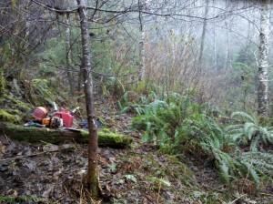 BEFORE: Proposed trail route heading through the South Seep.
The little Doug fir in front is suppressed, has a crooked top, and is right in the way, so it will be removed. The extensive brush in the background (mostly salmonberry) obscures the rest of the stand. It is old and is starting to die back due to lack of sunlight in this now closed-canopy alder grove.
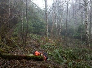 AFTER: Trail opened up through the South Seep.
Now we can see the individual trees and can walk through the forest easily. There is slash all over the ground on either side of the trail. I just slice up the cull trees, branches and brush to within a few feet of the ground, and let them decompose over time. I only pick them up and toss them if they are on the trail route.
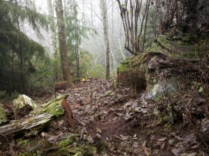 Looking back north along the trail into Alder Seep.
This is a nice raised, dry section between the seeps. Ancient cedar stumps and cut chunks are found wherever you turn in this area. I try to route the trail near the most interesting artifacts of this legacy forest.
Continue Reading | Comments Off on Trail creation through the South Seep
Forestry work in the Alder Seep
FORESTRY: 2.5 hours: 3:00 PM to 5:30 PM
Pre-commercial thinning, pruning and general clean-up in the Alder Seep and Cedar Shake Park in Eastern Wedge unit #5.
Forestry portion of new trail establishment in Eastern Wedge unit #5. Mostly thinning and pruning in the Alder Seep. Completed the section above the trail (top of the seep) up to the eastern property line. The alders have few, widely spaced branches, many of which are dead and pop right off. Most branches are small, as these alders are growing close enough to shade out the understory. A power pole pruner is needed to get the more numerous live branches higher up. Now is the perfect time to create a clean bole for peeler logs – the trees are tall enough (at 16 years old) to allow pruning of all branches that can be reached (up to about 16 feet) – just one lift (pruning) during the life of the tree. Continued pruning alder limbs and felling suppressed and deformed alders, hemlock and Doug fir from the Alder Seep up over the south bank into the next wet zone. Old cedar stumps and remnants of shake bolt cutting are everywhere in this unit.
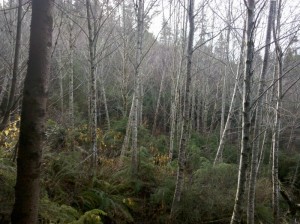 Mostly self-thinned 16 year-old alder in the Alder Seep.
This area was clear-cut sixteen years ago and replanted in Doug fir. Only one Doug fir is visible in the photo (the dark tree trunk on the left hand side), as the naturally regenerated alder quickly captured this wet site and shaded out the fir.
Cut down a few suppressed, bent-over and broken-topped alder, and pruned the low branches. This stand is in surprisingly good shape after surviving the Great Coastal Gale of 2007, and the natural spacing is about right for their age.
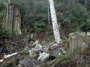 Cedar shake bolts and old cedar stumps in the Alder Seep.
There are old-growth Western Red Cedar stumps and logs all throughout Eastern Wedge unit #5. The forest floor is littered with the rectangular chunks (bolts) cut out of the cedar for shingles or roof shakes. This remnant cedar was highly sought after in recent decades by salvagers looking for the tight, straight grain and rot resistance found only in centuries-old wood.
Now covered in moss and lichen, there’s no telling how long ago these were cut out of the old cedar logs and split into chunks that could be hauled away on foot. Perhaps these chunks were rejects, or the cutters never came back to claim them. In any case, there are hundreds of these strewn over many acres in Eastern Wedge unit #5. Hence the name “Cedar Shake Park”!
Continue Reading | Comments Off on Forestry work in the Alder Seep
Trail creation through the Alder Seep
TRAILS: 3.5 hours: 11:30 AM to 3:00 PM
Trail creation through the Alder Seep and Cedar Shake Park in Eastern Wedge unit #5.
Trail creation in Eastern Wedge unit #5. Continued along the northern edge of Alder Seep, cutting through the dense brush and cull trees just below the line of old stumps. Rounded the corner and cut a route across the seep, using some cedar shake bolts as stepping stones across the broad wet zone. Continued up the bank on the southern side of the seep, heading south about a hundred feet towards the next, smaller wet zone – stopped due to darkness. Also discovered the eastern property line at the top of the Alder Seep – it is well-marked, with a rough surveying trail running along it – should return to this and do additional clearing for long-term maintenance along the line.
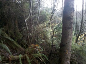 BEFORE (11:50 AM): Trail section to be blazed along the north edge of the Alder Seep.
Heavy brush and suppressed trees dominate this proposed trail section. Not the easiest way to route this trail, but it will run along the contour, highlighting a line of ancient cedar stumps on the uphill side and avoiding a steep drop to the wet area on the downhill side.
The “Alder Seep” is a wide , gently sloping depression in the hillside where water is oozing out from all sides, populated by young alder trees.
AFTER (1:24 PM): Trail opened up along the north edge of the Alder Seep.
Still a fairly rough terrain that will need to be carved out with a shovel and mattock to create a final grade.
Note the old stumps on the uphill side and the removal of suppressed trees along the route. Also pruned the low, dead branches on the remaining trees. Left the hemlock thicket intact above the stumps for wildlife cover.
Continue Reading | Comments Off on Trail creation through the Alder Seep
Forestry work around the Great Cedar Snag
FORESTRY: 2 hours: 3:15 PM to 5:15 PM
Thinning, pruning and general clean-up between Riparian Zone unit #3 and Eastern Wedge unit #5.
Forestry portion of new trail establishment into Eastern Wedge unit #5 from the Great Cedar Snag. Cull tree and decrepit brush removal along with lower branch pruning (mostly with the hand saw in tight quarters). Surprisingly, a large collection of established (16 year-old) Doug fir in this northern end of Eastern Wedge unit. These appear to have prevailed against the encroaching hemlock and alder found in much of this unit. Still, many of them have broken (but regrown) tops, or are suppressed to the point of failure, and some have twin trunks growing from the base, so there is plenty of cull material here. The Red Alder in the Alder Seep are amazingly well-spaced and robust for their young age, perhaps 30 feet tall and 6”-10” DBH, forming a nearly pure stand of alder. Quite a few have compromised (re-grown) tops, but this damage occurred at such a small diameter (high up on the tree) that it appears to have fully sealed the wound. Many of the alder are in perfect condition for their age. I cut out some of the obvious culls: the suppressed, bent-over, and the bad broken-tops.
Continue Reading | Comments Off on Forestry work around the Great Cedar Snag
Trail creation from Great Cedar Snag to Alder Seep
TRAILS: 4.5 hours: 10:45 AM to 3:15 PM
Trail creation through from Great Cedar Snag to the Alder Seep in Eastern Wedge unit #5.
Trail establishment into Eastern Wedge unit #5 from the NE corner of the RMZ. Started where I left off last time at the Great Cedar Snag – the top of the incline up through the RMZ from the upper creek crossing. Cut the trail through the brush and woody debris, roughly following the contour heading south, slightly descending down into the Alder Seep and Cedar Shake Park. Alder Seep is a shallow ravine with a lot of surface water spread over a wide area. Scattered throughout this small basin are monster old-growth cedar stumps and logs, with old shake bolts (cut by cedar shake salvagers) all over the ground. <Make note of this as a cultural site/artifact in the management plan.> Very difficult finding a good route through this steep and dense terrain, but ended up with a fairly level route that aims to cross the high side of the seep with a minimal water crossing. Much of this trail runs directly underneath many legacy stumps of the big trees that once dominated this landscape, so it should make for interesting hiking. Will have to return with shovel, mattock and axe to carve the path into the humus-y hillside, as it is too sloped to get a good footing. Associated cull tree removal and lower branch pruning on the Doug firs along the route. Also roughed out a side trail up the ridge from the Great Cedar Snag heading east to the property line.
Continue Reading | Comments Off on Trail creation from Great Cedar Snag to Alder Seep
Forestry work in Eastern Wedge hemlock thicket
FORESTRY: 1 hour: 4:30 PM to 5:30 PM
Pre-commercial thinning, pruning and general clean-up in the south end of Eastern Wedge unit #5.
Forestry portion of trail creation in Eastern Wedge unit #5. Cut out suppressed and damaged trees alongside the trail route, plus some low branch pruning. Originally estimated as a 20 year-old stand, the culled trees show it to be only 15 or 16 years old. This stand was replanted in Doug fir, but it has been overrun by hemlock in the higher, drier sections, and alder in the lower, wetter sections. Fortunately, the hemlock and alder have not grown into an un-differentiated thicket – there are many larger, well-spaced specimens that have achieved dominance, and timely thinning (now!) will consolidate their gains. Unfortunately, extensive damage is apparent (from approx. 6 years ago) in the form of bent, downed and broken-topped trees. Hurricane-force winds hammered this windward-facing slope during the Great Coastal Gale of 2007 (December 2nd & 3rd ). Nearby Naselle Ridge clocked the storm’s highest gust at 147 mph. The damage is similar to what would occur with snow/ice loading, but that type of event is extremely unlikely in this coastal setting. Will need to carefully examine tree tops for wholeness and good form during the thinning process.
Continue Reading | Comments Off on Forestry work in Eastern Wedge hemlock thicket
Trail creation from South Side into Eastern Wedge
TRAILS: 3 hours: 1:30 PM to 4:30 PM
Trail creation from South Side unit #4 into Eastern Wedge unit #5.
Trail creation from South Side unit #4 into Eastern Wedge unit #5. First, some final logs cut and tossed off the road; then cut through some stumps and downed logs past the South Side high landing into the young hemlock forest. Pierced the veil of brushy hemlock at the solar edge, cleared suppressed trees, brush and downed woody material, heading NE along the contour, about 100 feet into the stand. Very heavy growth in the understory took extra time to clear. Nearly impossible to sight through the terrain to see where the best route lays – just have to clean it up, prune off the low branches and slash the wood to the ground before a final trail route can be selected.
Continue Reading | Comments Off on Trail creation from South Side into Eastern Wedge
Monitoring check of salmon in creek
MONITOR: 0.5 hours: 1:00 PM to 1:30 PM
Looking for evidence of salmon spawning in Clearwater Creek, other photo-documentation.
Photo-documentation at Clearwater Creek property: salmon carcass in the creek, before-and-after photos at the main road junction in South Side unit #4.
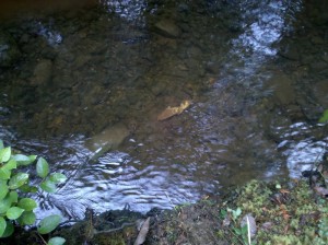 Finally a salmon carcass in the creek!
After months of checking the mouth of the creek (October through December), I spotted this bleached-out salmon carcass. I had only been checking this one spot, where the mouth of the creek meets high tide at the slough. This small slough empties into the tidal Naselle River as it blends into Willapa Bay.
Next year, I will check farther upstream (only a few hundred feet) where the salmon are likely spawning in a stretch with gentle riffles. Further up, the creek ascends quickly, and there are several waterfalls that look to be impassable to salmon.
Continue Reading | Comments Off on Monitoring check of salmon in creek
New trail from upper creek RMZ to Great Cedar Snag
TRAILS: 3.5 hours: 11:15 AM to 2:45 PM
Trail creation from the upper creek crossing through the RMZ to the Great Cedar Snag.
Opened up a new trail in the NE corner of the property, on the south side of the creek. Cut up a few small downed trees at the creek crossing where stepping stones make it easy to get across, at the eastern end of the north side trail. Cut a diagonal path up the fully-stocked hillside on the north side of the creek, heading SW, up several hundred feet to the Great Cedar Snag. Some large downed trees to cut through (see photo). Pulled out sword fern and other brush in the path way. Will need to carve into the bank and smooth out the path to create a relatively gentle grade up this steep section. Some rock outcroppings here as well. Some incidental stob pruning on the mature hemlocks and cedars. This trail will run through the Eastern Wedge unit #5 to hook up with the South Side High Road.
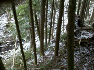 Looking down into Clearwater Creek from the south side.
A light dusting of snow on the ground as I opened up a trail from the upper creek crossing, climbing up the Eastern Hill. A very steep section through the established forest in the Riparian Management Zone (RMZ). These hemlocks and cedar, with a few alders mixed in, are 40-60 years old. The roughed-out trail ascends the hill along the extreme right edge of this photo.
State regulations prohibit harvesting of timber within a wide RMZ (over 100′ horizontally) along both sides of this salmon-bearing waterway.
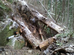 BEFORE : Downed trees lying across the trail half way up the Eastern Hill.
Lots of blown-down trees everywhere due to the Great Coastal Gale of 2007. The bedrock is exposed here (left side of photo) because a large tree uprooted (where I am standing) and fell down the hill to the right. More trees from up above are down across the proposed route for this trail. I’ve already started cutting them into chunks, and the rest will be gone shortly.
It’s hard to tell that there is a viable route for a trail here, but this ends up being the least lumpy path up the hillside.
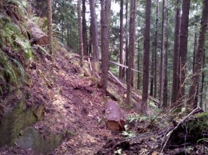 AFTER : Downed trees removed from the trail.
This “After” photo was taken about a week later, but this job took only a few hours to complete. The trail route is obvious now, and a little carving and finish-grading will make it look like its always been here!
Also did a very quick job cleaning up the forest along the trail route, pruning off low branches and cutting down the live “leaners”. Horizontal trees don’t have much of a future, so they are among the first to go.
Continue Reading | Comments Off on New trail from upper creek RMZ to Great Cedar Snag



 Spirulina