Archive for November 23, 2013
Plot new trail through Eastern Wedge unit
TRAILS: 0.5 hours: 2:15 PM to 2:45PM
Looked at potential trail routes through Eastern Wedge unit #5.
Scoped out new Eastern Wedge Unit #5, accessed from the top landing of the south side High Road. “Pierced the veil” of thick young hemlocks an entered an alder/hemlock forest, approx. 20 years old, that probably naturally regenerated from an earlier clearcut. Further on, ran into sections of a healthy Doug fir plantation of the same age class, which was probably planted after the clearcut, but was shaded out by the alder and hemlock in much of the area. Surprisingly, the hemlock and especially the alder seems to be robust and relatively well-spaced, although there is also a thicket of suppressed trees mixed in with the hemlocks. No sign of pre-commercial thinning in here, but now is a good time to do it comprehensively. Located a massive cedar stump with remnants of shake bolt cutting stretched over a 20-foot area. Will route the trail by this feature and highlight the cut pieces.
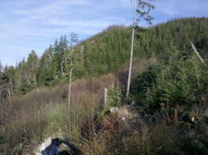
 Eastern Wedge unit viewed from the top of High Road.
This unit was harvested about 16 years ago, as part of the hillside in the background. The property boundary line runs horizontally across the hill about half way up. Doug fir was planted on the entire hillside, but on the lower part, in a wet depression, Red Alder (bare trees with a red tinge) overtook the fir and became the dominant species.
Originally included as part of South Side unit #4, this is a different age class (10 years older), a different topographic area (the East Hill) and also different silviculturally (a plantation versus natural regeneration), so I decided to create a new management unit for it: “Eastern Wedge #5”, because it is on the eastern edge of the property and it is wedge-shaped.
Continue Reading | Comments Off on Plot new trail through Eastern Wedge unit
High Road initial clearing
TRAILS: 1.25 hours: 1:00 PM to 2:15PM
Initial clearing of the top of High Road in South Side unit #4.
Started clearing the top part of the High Road in south side Unit #4, with the shovel and hand saw. The shovel broke after a few minutes, so I pulled as much of the alder and blackberry as possible Also tossed the sparse branches and log chunks off this wide road bed through the clearcut zone. Partially cleared just over 100 feet down from the landing at the top. Scattered small scotch-broom along the road and landing – tightly pruned into compact balls by the elk – and easy to pull out intact. Lots of tiny cedar seedlings taking root in the road – will come back later for transplanting.
Continue Reading | Comments Off on High Road initial clearing
Trail carving on south side creek bank
TRAILS: 1.5 hours: 11:30 AM to 1:00 PM
Carved trail up the south side bank at the lower creek crossing in RMZ unit #3.
Started carving the path up the bank on the south side of Clearwater Creek where the trail crosses near tidewater. Hacked out roots and rocks to create a level, gentle grade up from the stream bed. Carved about 15 feet in length to create a solid path, with about the same distance still to carve. Slow going but the end result is well worth it – a well sited and low gradient climb out of the stream basin in an otherwise steep and slippery area.
Continue Reading | Comments Off on Trail carving on south side creek bank


 Spirulina