Archive for December 13, 2013
Forestry work in Eastern Wedge hemlock thicket
FORESTRY: 1 hour: 4:30 PM to 5:30 PM
Pre-commercial thinning, pruning and general clean-up in the south end of Eastern Wedge unit #5.
Forestry portion of trail creation in Eastern Wedge unit #5. Cut out suppressed and damaged trees alongside the trail route, plus some low branch pruning. Originally estimated as a 20 year-old stand, the culled trees show it to be only 15 or 16 years old. This stand was replanted in Doug fir, but it has been overrun by hemlock in the higher, drier sections, and alder in the lower, wetter sections. Fortunately, the hemlock and alder have not grown into an un-differentiated thicket – there are many larger, well-spaced specimens that have achieved dominance, and timely thinning (now!) will consolidate their gains. Unfortunately, extensive damage is apparent (from approx. 6 years ago) in the form of bent, downed and broken-topped trees. Hurricane-force winds hammered this windward-facing slope during the Great Coastal Gale of 2007 (December 2nd & 3rd ). Nearby Naselle Ridge clocked the storm’s highest gust at 147 mph. The damage is similar to what would occur with snow/ice loading, but that type of event is extremely unlikely in this coastal setting. Will need to carefully examine tree tops for wholeness and good form during the thinning process.
Continue Reading | Comments Off on Forestry work in Eastern Wedge hemlock thicket
Trail creation from South Side into Eastern Wedge
TRAILS: 3 hours: 1:30 PM to 4:30 PM
Trail creation from South Side unit #4 into Eastern Wedge unit #5.
Trail creation from South Side unit #4 into Eastern Wedge unit #5. First, some final logs cut and tossed off the road; then cut through some stumps and downed logs past the South Side high landing into the young hemlock forest. Pierced the veil of brushy hemlock at the solar edge, cleared suppressed trees, brush and downed woody material, heading NE along the contour, about 100 feet into the stand. Very heavy growth in the understory took extra time to clear. Nearly impossible to sight through the terrain to see where the best route lays – just have to clean it up, prune off the low branches and slash the wood to the ground before a final trail route can be selected.
Continue Reading | Comments Off on Trail creation from South Side into Eastern Wedge
Monitoring check of salmon in creek
MONITOR: 0.5 hours: 1:00 PM to 1:30 PM
Looking for evidence of salmon spawning in Clearwater Creek, other photo-documentation.
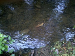
Photo-documentation at Clearwater Creek property: salmon carcass in the creek, before-and-after photos at the main road junction in South Side unit #4.
 Finally a salmon carcass in the creek!
After months of checking the mouth of the creek (October through December), I spotted this bleached-out salmon carcass. I had only been checking this one spot, where the mouth of the creek meets high tide at the slough. This small slough empties into the tidal Naselle River as it blends into Willapa Bay.
Next year, I will check farther upstream (only a few hundred feet) where the salmon are likely spawning in a stretch with gentle riffles. Further up, the creek ascends quickly, and there are several waterfalls that look to be impassable to salmon.
Continue Reading | Comments Off on Monitoring check of salmon in creek


 Spirulina